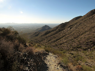
I spent my Saturday afternoon back up in the McDowells, this time hiking from the Gateway Trailhead up to Bell Pass. I've hiked the Gateway loop many times, but this was the first time I have ever been on the Bell Pass Trail. Wow, I have been missing out!
The Gateway Trailhead is located on the west side of the McDowell Sonoran Preserve off of Thompson Peak Road. It's very popular with hikers accessing the Gateway loop and some shorter nature trails that provide some awesome hiking opportunities for families with small kids or people who aren't interested in strenuous elevation gain. My route took me along the south section of the Gateway loop, reaching the Bell Pass Trail after 1.5 miles of flat hiking on a wide path. Along this section of the trail I saw alot of people out enjoying the beautiful weather.
 |
| Thompson Peak seen from the Bell Pass Trail |
 |
| Thompson Peak seen from the Bell Pass Trail |
 |
| The ribs of a Giant Saguaro |
 |
| Giant Saguaro |
Once I reached the Bell Pass Trail, the crowds dropped off
completely. Along the entire 2 mile trail up to Bell Pass I didn't see a
single person on the way up and only passed one group of a few people
on the way down. I don't know of many other trails that can give you
that level of solitude on a Saturday afternoon so close to an urban
environment.
The first mile or so of the Bell Pass
Trail is relatively flat. It travels through a canyon formed by Thompson
Peak towering overhead to the south and McDowell Peak to the north.
Along the way I saw a few mule deer, several different species of birds
and lizards, and tons of tall Saguaros.
 |
| Facing east towards the valley |
 |
| The beginning of the switchbacks |
The second mile
of the Bell Pass Trail picks up a majority of the elevation gain,
becoming much steeper. After a series of switchbacks the trail arrives
at Bell Pass, elevation 3,204 ft. The view is pretty great, providing a
360 degree panorama of the McDowell Mountains and the valley. Four Peaks
is visible to the east while looking to the west Camelback and the
Phoenix Mountain Preserve can be seen. Looking down at the valley makes
you feel like you are very high up (you are 1500 ft. above the trailhead
at this point) but McDowell Peak and Thompson Peak are still 700 ft.
above.
 |
| Looking down towards the start of the switchbacks |
 |
| Looking east towards the valley from the top of the switchbacks |
From Bell Pass you have several options to
continue hiking through the preserve. The trail continues half a mile
northeast to meet a fork. Heading right will take you to the Prospector
Trail, which links up the road to the top of Thompson Peak while heading
left will continue along the Bell Pass Trail to the East End Trail,
which can be taken all the way to the Tom's Thumb Trailhead or back to
the Gateway Trailhead via the Windgate Pass Trail. Since I started my
hike late in the afternoon I decided to turn around and head back down
the way I came. During winter months the park closes around 5:30 to
hikers in order to give the desert critters their own time in the
preserve.
 |
| Bell Pass |
 |
| Four Peaks seen from Bell Pass |
 |
| Facing east from Bell Pass |
 |
| Hedgehog Cactus |
 |
| Hedgehog Cactus |
 |
| Teddy Bear Cholla with Camelback Mountain in the background |
 |
| Facing west from Bell Pass |
I returned back down the Bell Pass Trail,
arriving at the Gateway loop during the golden hour. Sunset in the
desert is one of the coolest things about living in Arizona. As I got
back to the car I saw the most interesting thing I've seen in the
McDowells, a guy riding a unicycle with a mountain bike tire. I'm not
sure how that worked out for him but I think I'll stick to my own two
feet.
 |
| Descending the switchbacks |
 |
| Fishhook Cactus |
 |
| Saguaros along the trail with Thompson Peak in the background |
 |
| Teddy Bear Cholla and Giant Saguaro |
 |
| A bird nest in a Teddy Bear Cholla |
 |
| Looking back up at Thompson Peak from the Gateway Loop |
The Hike:
Gateway Loop/Bell Pass Trail to Bell Pass out and back, 7 miles, 1500 ft. elevation gain.
Leave No Trace!


No comments:
Post a Comment