Monday, September 14, 2015

Northerly Island


In 2010, a hundred years after Daniel Burnham proposed his 1909 Plan of Chicago, the Chicago Park District unveiled their own plan for Northerly Island. Last week, the park finally opened and I got a chance to visit this weekend while I was in town visiting family. While it has a long way to go I can’t wait to see how this area develops in the next few years. Most of the park remained fenced off and covered in erosion control matting while the prairie plants develop, but the potential for this place is immense.
 
Lake Michigan viewed from Northerly Island
Northerly Island remains the only component of Burnham’s original dream for the Chicago lakefront (he wanted 5 island parks!) that was ever built, and has served many roles since its construction was completed in 1925. It has hosted a World’s Fair in 1933, Meigs Field from 1946 to 2003, The Adler Planetarium (one of the best museums in Chicago) since 1930, one of my favorite concert venues (Charter One Pavilion/ FirstMerit Bank Pavilion) since 2005, and now will finally serve its original purpose. The 91 acre peninsula is being developed by the Chicago Park District to provide an urban greenspace that will feature beautiful views of the Chicago skyline and a calm retreat from city living. The park will feature native plants and will provide signage to educate visitors about the ecology of the Great Lakes. I’m so excited to see what the park will become, especially since for most of my life there has been talk to turn the area into an urban greenspace.

After Burnham’s death in 1912, the idea to put an airport on Northerly Island was suggested by a co-author on the Plan of Chicago, Edward H. Bennett. Although the airport, Meigs Field, was not able to be completed until 1946, it became famous throughout its 57 years of operation and the air traffic control tower still stands today. Microsoft Flight Simulator used Meigs Field as the default airport and I can remember being a kid sitting at the computer and flying around the city looking at the skyscrapers. The airport was commonly used by high profile visitors to the city who wanted to avoid attention and traffic caused by flying into O’Hare. While his father, Richard J. Daley, had expressed interest in closing the airport and turning it into a park, it was ultimately Chicago Mayor Richard M. Daley who dealt the fatal blow to Meigs Field. In 1996, after the park district refused to renew the airport lease, Meigs field was temporarily closed. After pressure from Springfield, the airport reopened and a 25 year lease was compromised between Chicago and the State of Illinois in 2001. On March 30th, 2003, Daley broke his compromise and sent demolition crews to Meigs Field, carving giant X’s in the runway and closing down the airport. 16 planes were stranded and had use the taxiway to takeoff from the defunct airport.

Daley’s actions remain highly controversial with proponents excited at the prospect of having a park that can be enjoyed by the public and opponents furious over the destruction of a beloved and unique airport. The controversy continued in 2006, when the city had to repay $1 million for misappropriation of funds from the FAA that were being used in the destruction of the airport and redevelopment of the park (that’s the Chicago way!).  However, this weekend as I walked through the park I could see that things ultimately wound up working out.

We entered the park near Adler Planetarium after a short walk over from my cousin’s condo in the south loop. Along the way we passed Burnham Harbor and all of the boats taking refuge from the morning’s storm. Saturday morning in Chicago was very stormy so there weren’t too many people out but when the clouds cleared up a bit we decided to make a break for it to check out the park. As we entered the park we passed 12th Street Beach House. The beach was closed but there was a nice walking path through the park. Any signs of the airport were completely erased with the exception of the control tower. The landscape had been transformed, rolling hills and a beautiful lagoon in place of the old runway. You could tell that vegetation was newly planted and much of the ground remained uncovered erosion mats. However, the plants that were blooming were very pretty. Next year at the height of the summer the wildflowers are going to look amazing. The views of the skyline were excellent. We also passed some public art which was very beautiful. A series of statues entitled “The Daphne Garden” by Dessa Kirk depicted 3 beautiful statues of Daphne ( a Greek Mythological figure) made out of repurposed scrap metal.

Daphne Garden by Dessa Kirk
Daphne Garden with First Merit Bank Pavilion and the skyline in the background


The lagoon


There were fences up along the whole paved path to deter people from walking out onto the newly established vegetation but I was able to get a few nice pictures of wildflowers blooming at the tail end of the summer bloom. The park’s plan calls for certain areas to be open to people wandering and certain areas preserved from people, which will be awesome because it will allow people access to outdoor recreation while also creating restored prairie habitat. The city is also planning on installing a reef along the shore. It’s so cool to see more and more urban greenspace popping up in cities around the country. The importance of people’s relationship with the outdoors is becoming a central theme in design and urban planning and I am so excited to see the way the park looks when it is completed in a few years. 

Friday, September 11, 2015

My first trip into Utah: Bryce Canyon and Zion National Parks

After posting about Zion and not saying much about Angel’s Landing I feel compelled to talk about my experience with the hike last year and the rest of my trip which included a stop in Flagstaff, Page, and Bryce Canyon National Park. I hadn’t even heard of Angel’s Landing before last summer and had been planning on hiking the Grand Canyon Rim to Rim during fall break last year. However, similar to the way our Sequoia/Kings Canyon hike came about, our permit was denied due to the popularity of the hike and we were left looking for a different adventure. I had first heard of Angel’s Landing a few months before while talking to someone I met on a weekend camping trip at the south rim of the Grand Canyon. He had said that the hike was the most intense hike he had ever done due to the steep drop-offs and that at some points you had to hang onto chains so that you wouldn’t fall off the edge. This guy was a firefighter and he was telling me that he was uncomfortable on a hike. I wondered why the hell anyone would want to subject themselves to something like that.

I went home and did a search for Angel’s Landing and quickly figured out why. The view was so incredibly beautiful. I had never been to Zion or even into the state of Utah but all of the sudden I wanted to go. I watched countless youtube videos of people’s go-pro footage of the hike. My palms sweated and I gripped the edge of my seat as I watched but I HAD TO DO IT. Fast forward 3 months later and we were all set to head up into Utah. The disappointment of having our Grand Canyon permit denied was barely on our minds with the excitement of such a great alternative. After my dad and our family friend arrived in Phoenix we made our way up to Flagstaff for the first stop on our journey: Lockett Meadow.

Lockett Meadow sits in the Inner Basin of the Kachina Peaks near Flagstaff. While much of the Coconino National Forest is Ponderosa Pine, the Inner Basin is special because it is completely covered in a grove of Quaking Aspen. This was mid October and the golden fall colors were in full force. We only spent an hour or so in Lockett Meadow but we got some amazing pictures and enjoyed a picnic surrounded by some of the best fall colors I’ve ever seen.

Quaking Aspen in Lockett Meadow
A view of Kachina Peaks from Lockett Meadow
From Lockett Meadow we continued on to Bryce Canyon. We arrived in the park in the evening and were able to find a campsite at North Campground pretty easily, which is good because the campground is completely first come first served. After a brief view of the hoodoos in the twilight we had an amazing jambalaya dinner and headed to bed. Bryce Canyon is an amazing place because of its incredible geology. The canyon, which isn’t really a canyon in the true sense of the word, is filled with hoodoos, spires of rock formed by erosion. The hoodoos tower throughout the landscape, with reds, oranges, and whites creating an eye catching contrast to the blue sky and green coniferous trees. As the rim of the canyon is situated between 8,000 and 9,000 ft. it is significantly colder than Zion and some of the neighboring terrain. Coming from the warmth of the Phoenix valley, we definitely felt the chill overnight.

Sunset at North Campground
We were up at dawn the next morning to catch the sunrise over the hoodoos, one of the best sunrises I've ever seen. As the canyon below us glowed in the morning sunlight I couldn't wait to get out on the trail to explore. We followed the spectacular views with an epic breakfast of pancakes and bacon, complete with a bacon sandwich made with bread fried in bacon grease. We tore down camp and began our day of hiking. 

Sunrise at North Campground
Taking in sunrise
The bacon sandwich
We drove out to Fairyland Point to begin our hike on the Fairyland Loop, an 8.1 mile trail that dips 600 ft. down into the canyon before climbing 950 back up to the rim, weaving through hoodoos along the way. The trail provided a chance to see Sinking Ship, a giant rock that looks exactly like its nomenclature, and Tower Bridge, a famous rock formation. We spent approximately 5 hours exploring on our day hike.

Fairyland Loop Trail
A view of Sinking Ship from Fairyland Loop Trail
Fairyland Loop Trail
Tower Bridge
Fairyland Loop Trail
After completing our dayhike we drove out to Inspiration Point to watch the sun set over the hoodoos as we enjoyed a picnic and some cold beers. From there we made the (hour and a half) drive west to Zion National Park.

Inspiration Point
Due to the popularity of Zion and our late booking of the trip we weren’t able to find a campground in the park for both Saturday and Sunday night. Instead we spent the first night at the Zion Canyon Campground, a private campground run by the Quality Inn. It wasn’t what we were hoping for. The campground consisted of a big parking lot behind the hotel with cars parked right alongside one another and tents pitched on small patch of dirt right behind the cars. We were so crowded next to our neighbors that you could hear when someone farted in a tent a few campsites over. There was also an RV park immediately next to all the tent campers and we spent a good portion of the night laying awake listening to techno music being played by some drunk Germans in a rented RV.  

We woke up very early the next morning and tore down camp, heading from Springdale into Zion and boarding a shuttle bound for the Grotto, where we would begin our hike up Angel’s Landing. The hike up Angel’s Landing is intense. The trail climbs 5.2 miles up 1500 ft. and along the way encounters some of the craziest switchbacks in the NPS system at Walter’s Wiggles, dramatic views of Zion Canyon at Scout Lookout, and narrow paths with enormous drop-offs that make your palms sweaty just looking at photos. 5 people have died on the trail due to “nonsuspicious” falls (In Chicago all falls are “nonsuspicious”), and while the NPS does a great job of keeping the trail safe and providing adequate warning on signage, it’s understandable how someone could fall from the trail on a windy or icy day.

From the shuttle we began the hike along the Virgin River towards the trailhead. Along the way we spotted a huge tarantula slowly crawling along the sand, which seemed to freak out some of our fellow hikers more than the fact that they were about to do something that could potentially result in a fall to their death. After reaching the trailhead we began a series of paved switchbacks up the west side of Zion Canyon until we reached a narrow slot canyon called Refrigerator Canyon (and it is much cooler in the shade) that took us through the dark passage to Walter’s Wiggles.

Tarantula
Trail to Angel's Landing
Switchbacks up to Refrigerator Canyon
Refrigerator Canyon
Walter’s Wiggles is a series of 21 switchbacks that remind me of Lombard Street in San Francisco on first glance. Named after Walter Ruesch, who was responsible for building the trail to Angel’s Landing, the switchbacks are very tight and climb 250 feet up to Scout Lookout.

Walter's Wiggles
At Scout Lookout we get our first views of Zion Canyon since entering Refrigerator Canyon. It was so amazingly beautiful. We also get our first view of the last half mile of the trail, the section with the steep drop and the chains. For those who aren’t into heights, this is a good spot to turn around, but we would be continuing on. After a few photos from Scout Lookout, we begin our climb up the chains. The trail became more of a scramble than a hike and in steeper sections there were chains to hold on to (which is very difficult when you’re sweating buckets out of your palms). At one point my dad looked back at me and started laughing, my knees were shaking. I did my best not to look down but eventually curiosity and the desire to get some photos got the best of me. I don’t remember much of the hike except being pretty terrified but within 20 minutes or so we were standing at the top of Angel’s Landing.

View from Scout Lookout
Steep climb up the chains
Trail to Angel's Landing
This is where my knees were shaking...
Dad 
Eric attempts to navigate around a tree
The final section of chain to the top
The view from the top is so amazing. The sense of accomplishment (and relief) that you feel standing there is pretty rewarding. I also remember standing on the top as being so special because as I pulled out my phone to take some pictures I received a message from one of my best friends that he had gotten engaged the night before. Between the good news and the excitement of conquering my fear of heights, I was in a really good place. We spent a good half hour at the top, fending off chipmunks who were relentless in the pursuit of our snacks.

View from the top of Angel's Landing, looking south into Zion Canyon
By the time we had savored the view the trail had gotten a lot more crowded, which was pretty terrifying. The unfortunate thing about Angel’s Landing and its popularity is that it draws a lot of people who aren’t experienced and haven’t bothered to learn the rules of sharing a trail. There were no shortage of clowns with their go-pro selfie sticks blasting shitty dubstep music on portable speakers and at one point we had to basically yell at a guy for climbing on top of us as we tried to make our way back. We descended uneventfully back the way we came with a huge sense of relief. We spent the rest of the day doing some more hiking at emerald pools and the watchman trail before one last nice dinner by the campfire. Our family friend is one of the best chefs I know and he made the best meatballs and pasta that I’ve ever had using the Dutch oven and campfire. We packed up our tent the next morning and made our way back towards Phoenix.

Dipped our feet into the Virgin River after the strenuous hike
Monarch Butterfly on some Rabbit Brush
We did have one last stop in Page on the way home, Upper Antelope Canyon. Sitting on private Navajo land near Page, Antelope Canyon is one of the most photographed and famous sites in the southwest. It’s a narrow slot canyon carved through Navajo Sandstone and its flowing walls have attracted photographers from across the world. In December 2014, a photo taken by Peter Lik of a ray of light illuminating dust thrown into the air inside the canyon (dubbed “The Phantom”) was sold for a world record $6.5 million. While my photography skills weren’t nearly on that level, we did get some very nice pictures with the help of our Navajo guides, who are required to take you through the canyon. The canyon is divided into Upper Antelope Canyon, accessible by taking an offroad truck ride a few miles to the mouth of the bottom of the canyon, and Lower Antelope Canyon, which requires visitors to descend a set of ladders from the top. We visited Upper Antelope Canyon, which seems to be the more popular of the two with tourists. After completing our tour we headed back home.
The wash leading into Upper Antelope Canyon
Upper Antelope Canyon
Photographers in Upper Antelope Canyon
Upper Antelope Canyon
We had crammed in a long weekend of 2 National Parks, a National Forest, and a Navajo Tribal Park. Not a bad alternative to our original plan of hiking the Grand Canyon Rim to Rim, which we’ll be finally doing next month after 2 more attempts to secure a permit. My first trip into Utah was also one of the best outdoor experiences I’ve ever had and it was easy to see why I would be so eager to get back to Zion last week.

The Hikes:
-          Bryce Canyon National Park: Fairyland Loop, 8.1 miles roundtrip, 950 ft. elevation gain
-          Zion National Park: Angel’s Landing, 5.2 miles roundtrip, 1,500 ft. elevation gain

Leave no trace!


Tuesday, September 8, 2015

Zion National Park: Emerald Pools, Observation Point, & The Narrows

Panorama at Observation Point
I’ve been incredibly lucky in that I’ve gotten to spend 3 out of my past 4 Labor Day weekends in National Parks: 2012 hiking Mt. Leconte in the Smokies, 2013 hiking South Kaibab-Bright Angel Trail in the Grand Canyon, and this year hiking Observation Point and the Narrows in Zion National Park. Like millions of Americans and visitors from across the globe I loaded up my gear and set out to enjoy the tail end of summer outdoors. This trip was especially important because it was planned by one of my best friends in Denver and it was going to be a reunion not just for us but also for several friends coming from Dallas, Lexington, Seattle, San Francisco, and Phoenix. We would be meeting in Zion National Park for a weekend of exploring the scenery of southern Utah. Zion is one of the most popular parks in the NPS system. Last year it ranked #7 with 3.2 million visitors and from our conversations with park rangers this weekend 2015 is looking like it may top 4 million.This Saturday alone there were 39,000 rides taken on the shuttle system. While the park gets nearly as many annual visitors as Yosemite, it is only 1/5 the size, making it seem very crowded. Located only a few hour’s drive from Las Vegas and positioned in the middle of a circuit of national parks popular with international visitors and citizens of the U.S. alike, Zion features two of the most unique day hikes in the NPS: Angel’s Landing and The Narrows. 

With a late afternoon departure from Phoenix on Friday, we cruised up I-17 past Flagstaff and through Page. After crossing into Utah and winding through the Zion Tunnel we pulled into Zion just around midnight. We were camped at the Watchman Campground, which is one of my favorite campgrounds that I've ever stayed at. It's clean, has a badass name, and has an incredible view of the Watchman, a giant rock spire along the southeast walls of the canyon. The campground is filled with sunflowers and beautiful Sacred Datura. It's also a really common place to see Mule Deer. 

Mule Deer making his way through our campsite at breakfast
The view from Watchman Campground, Loop F
The Watchman
Sacred Datura. This is poisonous, do not eat it.
After a few hours’ sleep and a quick breakfast we were on the shuttle bus headed to our first set of morning hikes. Most of our group was headed to the Grotto to begin the strenuous and vertigo inducing hike up to Angel’s Landing. At just over 5 miles round trip with 1500 ft. of elevation gain along a steep path with thousand foot drops on either side, the hike is incredibly popular and draws huge crowds for the incredible views, but is pretty rough for folks who are afraid of heights. As we had both previously done the hike before and both have a pretty big fear of heights (I’ll write about that trip tomorrow), one of my friends and I would be forgoing another ascent in favor of a relaxing hike through Zion Canyon up to Emerald Pools and a more strenuous hike in the afternoon up to Observation Point. We split up into our respective hiking groups, boarded the shuttle, and made our way up into the canyon for the day. We hopped off the shuttle at the Court of the Patriarchs, a set of 3 tall sandstone cliffs named after biblical figures Abraham, Isaac, and Jacob. Utah was settled primarily by Mormons in the mid 19th century and as a result much of Zion’s features are named with a mixture of references to Mormon faith and names given to the area by its earlier inhabitants, the Paiutes. The park was actually originally named Mukuntuweap National Monument when it was formed in 1909. However, the park was renamed in 1918 to Zion, the name given to the area by Mormon settlers. 

Court of the Patriarchs
Western Scrub Jay
Angel's Landing viewed from the trail to Emerald Pools
We hiked 1.2 miles among prickly pear and mule deer along the Virgin River to Zion Lodge and the trailhead to Emerald Pools, a series of pools and waterfalls known for their distinct green coloring. If you like stagnant water, this hike is definitely for you! We hiked 3 miles round trip along the Emerald Pools Trail  to get a look at all 3 of the pools and take in the scenery of the canyon behind us. After reading that the area was a popular place to see Canyon Treefrogs, I spent a good portion of our time along the trail looking for one but was disappointed at the lack of amphibians, something that became a running joke over the course of the weekend whenever we approached a scenic view ("This place sucks, there aren't even any frogs").We finished the hike by following the Virgin River north to the Grotto and caught the bus to take us to Weeping Rock for our longer and steeper hike up to Observation Point.
Waterfall at Lower Emerald Pool
Upper Emerald Pool. Not pictured: Middle Emerald Pool
(because the middle child is always forgotten about)
The hike up to Observation Point follows an 8 mile round trip trail with 2100 ft. of elevation gain. The hike provides a dramatic view looking south into Zion Canyon with Angel’s Landing in the foreground some 700 ft. below Observation Point’s 6,507 ft. mesa. I’m not sure whether it’s the extra length and elevation or simply the fact that the trail isn’t as famous, but it was so much less crowded than the other trails we hiked over the weekend. The trail began with a series of paved switchbacks that carried us up the eastern side of the canyon. 

The view from the switchbacks up to Observation Point
After reaching the top of the switchbacks the trail entered Echo Canyon, which provided a more level path with nice shade from the canyon walls. This was an excellent spot to take a break in between strenuous climbs. 
Hiking through Echo Canyon
Echo Canyon
Echo Canyon
After leaving Echo Canyon, the switchbacks continued and we began to approach the rim of Zion Canyon. These switchbacks were the site of one of our craziest encounters with nature. As we climbed the switchbacks and took in the dramatic views I nearly jumped over the edge when a 3 foot long snake popped out of the bushes along the trail. As I tried to take pictures of the snake, I realized that it had seen a lizard on the trail behind me. Despite my numerous warnings to the lizard to run away from its impending doom, I watched in horror as the snake darted past me and gobbled up the lizard before the poor little guy even knew what was happening. RIP lizard.

Switchbacks from Echo Canyon to Observation Point
Striped Whip Snake  devouring a lizard
As we finished the last switchback we came to the flat mesa that sits at the top of Zion Canyon. We had arrived at Observation Point after nearly 2 hours of hiking and began taking in the incredible view of the canyon. The view is extremely similar to Angel’s Landing just a bit higher. It was so cool to see the canyon from this higher vantage point and I was in awe of how beautiful the park was. After a brief rest at the top we began our descent back into the canyon and hopped aboard the crowded shuttle to head back to camp for dinner and some stargazing. 

Observation Point
Aster on top of Zion Canyon
Beginning the hike back down into Zion Canyon
On Sunday morning we filled up on a breakfast of pancakes, sausage, and eggs in preparation for our hike up the Narrows, probably the most famous hike in Zion and possibly the NPS. If you haven’t heard of the Narrows, the hike features a trek through the Virgin River at the northern end of Zion Canyon. However, at this part of the canyon, the river is contained within the narrow walls of a slot canyon and the hike requires wading upstream through water that varies from ankle deep to “balls-deep” as one of our friends would say. With a permit and proper technical climbing equipment the Narrows can be a 16 mile round trip backpacking adventure. However, without a permit day hikers can only go as far as Big Spring, 5 miles upstream from the Temple of Sinawava, the last stop on the shuttle. We hopped on the shuttle around 8:30 AM. Earlier is better when hiking the Narrows as it is extremely crowded. You can tell who is headed up the Narrows because many people rent waterproof boots and hiking sticks from one of the outfitters located just outside the visitor center parking lot in Springdale. After about 35-40 minutes on the shuttle we arrived at the Temple of Sinawava and began a scenic 1 mile hike up the riverside walk, a paved trail along the Virgin River with beautiful hanging gardens growing from the canyon’s walls.

Riverside Walk from Temple of Sinawava to the Narrows
Hanging Gardens along the Riverside Walk
When we arrived at the start of the Narrows there were hundreds of people beginning their hike. It’s worth noting that the Narrows can become extremely dangerous during times of high river flow and can be extremely susceptible to flash flooding so always be sure to check conditions before heading out. Signage at the shuttle stop marks the risk level of entering the Narrows and everything indicated low risk on the morning of our hike. As we headed upstream I began to feel incredibly grateful that I had a trekking pole to keep my balance because the riverbed can change from smooth sand to rocks quickly, and for someone with my complete lack of grace this can lead to some pretty nasty spills into the cold water. We passed Mystery Falls, a 110 foot waterfall down the side of the canyon and continued into the dark slot canyon passing large crowds of people.

Mystery Falls
The Narrows
"Speak softly and carry a big stick" - T.R.
The good thing about the hike is that as you get deeper into the canyon the crowds seem to slowly dwindle from the massive pack at the beginning. Turning around and looking downstream can make you feel like you're in an episode of the walking dead, especially the way people trudge upstream like a pack of zombies over the rocks in the river. While you never really get a sense of solitude (at least not on the Sunday of Labor Day) it’s still a very peaceful hike once you get a few miles upstream. Most people don’t go all the way to Big Spring and we didn’t either. At the 2.5 mile mark we approached a fork for Orderville Canyon and veered right, hiking a half mile or so up the canyon. Orderville Canyon was much more narrow in some parts but featured lots of beautiful vegetation and a few waterfalls. To continue up Orderville Canyon permits are needed so we headed back downstream to beat some of the crowds. After almost 5 hours of hiking we made it 3 miles upstream and back. The crowds had grown even more as we approached the riverside walk and it felt almost like we were walking down a city street.

The Narrows
The Narrows - Approaching Orderville Canyon
Entering Orderville Canyon
Orderville Canyon
Orderville Canyon
Orderville Canyon was full of beautiful vegetation.
Orderville Canyon
The Narrows
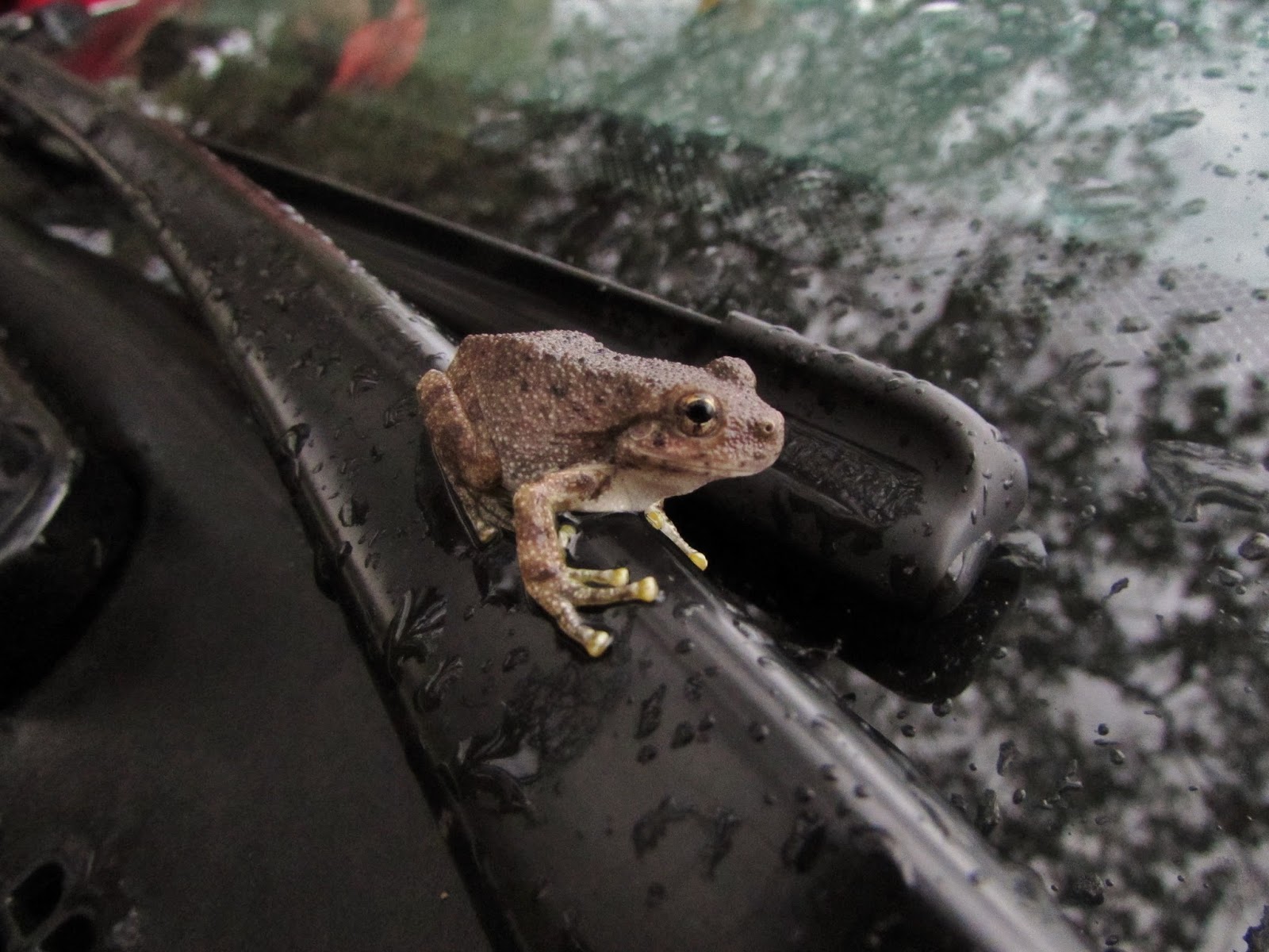
After getting back to camp we enjoyed a great dinner before a quick sunset hike and a trip into Springdale for some ice cream. After a long day of hiking we were in bed pretty early but didn't get much sleep due to a passing storm which left us with some pretty wet camping gear. We were really grateful that the weather as so good to us all weekend and only waited until our last few hours in the park to give us some rain. We woke up at dawn to pack away our gear and say our goodbyes while we thought about where our next trip would be. As we loaded our gear into the car and attempted to drive away I realized that I had left my phone charging too long on my car battery and as a result would not be able to start my car. Luckily a park ranger came to our rescue and with a quick jump we were on our way back to Phoenix, but not before spotting something I had hoped to see all weekend hanging out right on my windshield wiper.

Canyon Treefrog
The Hikes:

- Emerald Pools: 3 miles round trip, 350 ft. elevation gain 
- Observation Point: 8 miles round trip, 2100 ft. elevation gain
- The Narrows to Orderville Canyon: 6 miles round trip, not much elevation gain

Enjoy the outdoors and Leave No Trace!