Showing posts with label Utah. Show all posts

Thursday, January 14, 2016

Monument Valley, Arches, and Breckenridge

The past few weeks have been pretty unforgiving in terms of letting me get out for a hike so today I'm reminiscing about my trip up to Arches National Park last January. Like so many of the coolest trips I did while I was in grad school, this was a spontaneous one. A friend from Denver called me and told me that they had an open spot on a ski trip in Breckenridge that weekend and since I was back in Arizona waiting for the semester to start I had no excuse not to make the drive. I had never snowboarded in Colorado so that was appealing in itself, but the trip would also give me an excuse to make my first trip to two iconic landscapes of the west: Monument Valley and Arches National Park.

Leaving Phoenix at dawn, I drove up I-17 into Flagstaff, passing the snow capped Kachina Peaks. Only a 2 hour and change drive from Phoenix, I had entered a different climate entirely and I began to see drifts of snow along the highway. As I headed northeast through Navajo Nation past Tuba City and into Kayenta, I began to see the silhouettes of the sandstone bluffs that define Monument Valley in the distance. Ask anyone to describe the quintessential scene of the west and they will without a doubt think of Monument Valley. Crossing into Utah I entered Monument Valley Navajo Tribal Park and stopped along highway 163 for some photos.


Determined to reach Arches National Park in time to hike out to delicate arch for sunset I continued north through Mexican Hat, Utah, named for a rock that vaguely resembles a man wearing a sombrero. I pulled over to see Mexican Hat Rock and I felt a little sad for it because had it been located somewhere in the midwest people would probably seek it out as a hiking destination or geologic landmark. However, being in Utah among some of the country's most impressive geology, Mexican Hat Rock amounted to not much more than a mediocre heap of rock. Poor Mexican Hat Rock.


I continued north and reached Moab in the late afternoon. Navigating my way through the main street of town, Highway 191, every building I passed seemed to cater to outdoorsmen. Rock climbing equipment, kayaks, mountain bikes, and camping gear seemed more easily accessible commodities than groceries. Moab is an interesting town. A small town with a population of only 5000 residents, the tourism industry brings over a million visitors each year. In American history Moab has been the home of indigenous people, the site of a trading fort, Japanese internment camp, and Uranium mining community. Once deemed "The Uranium Capitol of the World", by 1980 the mines had closed and the town became one of the top outdoors destinations in America.

A large reason for its attraction from tourists and outdoorsmen is the proximity to two beautiful National Parks: Arches (located just north of town across the Colorado River) and Canyonlands (located only 30 miles southwest). En Route to Breckenridge I would be camping for the night at Arches National Park in the Devil's Garden Campground. This would also be another first for me in that I had never winter camped before, but I had faith in my sleeping bag. After a quick stop at the visitor center I drove up the park's main road, climbing in elevation to some beautiful views of Moab below until I reached the plateau that holds the national park. To the southeast I could see the La Sal Mountains, coated in snow and providing a stark contrast to the red terrain in the foreground.

Arches National Park began as Arches National Monument, designated in 1929. It was changed to become Arches National Park in 1971. Although the park is relatively small compared to other sites in the NPS at approximately 120 square miles, what it lacks in size it makes up for in beautiful views and iconic rock formations. The park is home to over 2000 natural arches, formed over millions of years by erosion of its red sandstone deposits. While it's prohibited to climb on any of the natural arches, there is still some pretty awesome rock climbing and the hiking is excellent. Perhaps the most well known of the arches in the park is Delicate Arch, which is featured in the background of the Utah state license plate. It was here that I decided to start my first hike.

The hike out to Delicate arch is 3 miles round trip with approximately 500 ft. elevation gain. Beginning at the Wolfe Ranch Trailhead, the first quarter mile of the trail provides an opportunity to see some petroglyphs created by the Utes who once inhabited the area. The trail is extremely popular, and despite winter conditions I still saw 30-40 people along the hike to the arch. Summer months are even more crowded. After hiking along a well defined path the trail turned to slickrock marked by cairns. After a few close calls on the icy trail I arrived at the arch in time for sunset. The views of the arch with the La Sal Mountains in the background were absolutely incredible and in the light the arch glowed bright orange.


I made my way back across the slickrock in the last few minutes of sunlight and headed to the Devil's Garden Campground, a nice facility of 51 campsites. $25 a night gets you flush toilets, fire pits, and picnic benches. As the sun dropped below the horizon the temperature dropped below freezing and I opted to spend the night sprawled in the back of my car instead of in my tent. I had the entire campground to myself that night.


I woke up before sunrise feeling pretty warm (Sierra Designs Zissou sleeping bag is rated to 23 degrees, which happened to be the temperature outside) only to see that my breath had condensed on the inside of my windshield to create a thick layer of frost. This marked the first time I've ever had to use a windshield scraper on the inside of my car. After a quick breakfast of oatmeal and coffee I left my campsite and started my morning hike: The Devil's Garden Primitive Loop, a 7.2 mile loop with 350 ft. elevation gain that provides excellent up close views of dozens of the park's arches. Traveling in a clockwise direction, the first half mile or so of the trail was relatively flat with few arches.


After just under a mile of hiking I reached Landscape Arch. Spanning 290 feet across, Landscape Arch has the largest span of any arch in the park. I arrived at the arch just after sunrise which created another beautiful glow on the red rocks.


After passing Landscape Arch the trail began a steep elevation gain up to a fork for Partition Arch and Navajo Arch. The icy trail was pretty difficult to climb and at some points I wound up sliding back 50-100 feet, which was amusing and scary at the same time.


After passing Partition Arch and Navajo Arch I reached the high point of the trail, which provided some pretty stunning panoramic views of the park.


The next arch I approached was Double O Arch, which also marked the fork for a half mile trail that dead ended at the Dark Angel, a 150 ft. tall sandstone formation. I returned to the main trail and completed the latter half of the hike, which featured fewer arches but was still beautiful. After wandering through some canyons and back through the field where the trail began I arrived back at the trailhead and began my drive northeast to Colorado.


Along the way I stopped at several of the vista points: the fiery furnace, which can be hiked in the summer after obtaining a permit and proper training to avoid damaging the cryptobiotic soil; balanced rock; and petrified dunes, which were formed as pressure transformed ancient sand dunes into the present day sandstone hills that sit in the foreground of the La Sal Mountains.


After leaving the park I continued north until I reached I-70, which took me east into Colorado. I followed the Colorado River into the mountains, arriving in Breckenridge just in time for dinner and sharing a few beers with friends. We spent the next day on the mountain and the snowboarding was the best that I've ever experienced (as a boy from the midwest). Paired with the incredible views of the mountains I was extremely glad I decided to make the trip.


After spending the night in Denver on a friend's couch I made the long trek back to Phoenix, this time via I-25 through scenic New Mexico. The amazing views continued and I reached Phoenix late at night, amazed at how many incredible sights I had seen in only 4 short days.


The Hikes:
Delicate Arch Trail - 3 miles round trip, 500 ft. elevation gain
Devil's Garden/Primitive Loop - 7.2 miles round trip, 350 ft. elevation gain

For more info on Monument Valley Navajo Tribal Park, Arches National Park, or Breckenridge check out these links:
http://navajonationparks.org/htm/monumentvalley.htm
http://www.nps.gov/arch/index.htm
http://www.breckenridge.com/

Leave No Trace!

Tuesday, September 8, 2015

Zion National Park: Emerald Pools, Observation Point, & The Narrows

Panorama at Observation Point
I’ve been incredibly lucky in that I’ve gotten to spend 3 out of my past 4 Labor Day weekends in National Parks: 2012 hiking Mt. Leconte in the Smokies, 2013 hiking South Kaibab-Bright Angel Trail in the Grand Canyon, and this year hiking Observation Point and the Narrows in Zion National Park. Like millions of Americans and visitors from across the globe I loaded up my gear and set out to enjoy the tail end of summer outdoors. This trip was especially important because it was planned by one of my best friends in Denver and it was going to be a reunion not just for us but also for several friends coming from Dallas, Lexington, Seattle, San Francisco, and Phoenix. We would be meeting in Zion National Park for a weekend of exploring the scenery of southern Utah. Zion is one of the most popular parks in the NPS system. Last year it ranked #7 with 3.2 million visitors and from our conversations with park rangers this weekend 2015 is looking like it may top 4 million.This Saturday alone there were 39,000 rides taken on the shuttle system. While the park gets nearly as many annual visitors as Yosemite, it is only 1/5 the size, making it seem very crowded. Located only a few hour’s drive from Las Vegas and positioned in the middle of a circuit of national parks popular with international visitors and citizens of the U.S. alike, Zion features two of the most unique day hikes in the NPS: Angel’s Landing and The Narrows. 

With a late afternoon departure from Phoenix on Friday, we cruised up I-17 past Flagstaff and through Page. After crossing into Utah and winding through the Zion Tunnel we pulled into Zion just around midnight. We were camped at the Watchman Campground, which is one of my favorite campgrounds that I've ever stayed at. It's clean, has a badass name, and has an incredible view of the Watchman, a giant rock spire along the southeast walls of the canyon. The campground is filled with sunflowers and beautiful Sacred Datura. It's also a really common place to see Mule Deer. 

Mule Deer making his way through our campsite at breakfast
The view from Watchman Campground, Loop F
The Watchman
Sacred Datura. This is poisonous, do not eat it.
After a few hours’ sleep and a quick breakfast we were on the shuttle bus headed to our first set of morning hikes. Most of our group was headed to the Grotto to begin the strenuous and vertigo inducing hike up to Angel’s Landing. At just over 5 miles round trip with 1500 ft. of elevation gain along a steep path with thousand foot drops on either side, the hike is incredibly popular and draws huge crowds for the incredible views, but is pretty rough for folks who are afraid of heights. As we had both previously done the hike before and both have a pretty big fear of heights (I’ll write about that trip tomorrow), one of my friends and I would be forgoing another ascent in favor of a relaxing hike through Zion Canyon up to Emerald Pools and a more strenuous hike in the afternoon up to Observation Point. We split up into our respective hiking groups, boarded the shuttle, and made our way up into the canyon for the day. We hopped off the shuttle at the Court of the Patriarchs, a set of 3 tall sandstone cliffs named after biblical figures Abraham, Isaac, and Jacob. Utah was settled primarily by Mormons in the mid 19th century and as a result much of Zion’s features are named with a mixture of references to Mormon faith and names given to the area by its earlier inhabitants, the Paiutes. The park was actually originally named Mukuntuweap National Monument when it was formed in 1909. However, the park was renamed in 1918 to Zion, the name given to the area by Mormon settlers. 

Court of the Patriarchs
Western Scrub Jay
Angel's Landing viewed from the trail to Emerald Pools
We hiked 1.2 miles among prickly pear and mule deer along the Virgin River to Zion Lodge and the trailhead to Emerald Pools, a series of pools and waterfalls known for their distinct green coloring. If you like stagnant water, this hike is definitely for you! We hiked 3 miles round trip along the Emerald Pools Trail  to get a look at all 3 of the pools and take in the scenery of the canyon behind us. After reading that the area was a popular place to see Canyon Treefrogs, I spent a good portion of our time along the trail looking for one but was disappointed at the lack of amphibians, something that became a running joke over the course of the weekend whenever we approached a scenic view ("This place sucks, there aren't even any frogs").We finished the hike by following the Virgin River north to the Grotto and caught the bus to take us to Weeping Rock for our longer and steeper hike up to Observation Point.
Waterfall at Lower Emerald Pool
Upper Emerald Pool. Not pictured: Middle Emerald Pool
(because the middle child is always forgotten about)
The hike up to Observation Point follows an 8 mile round trip trail with 2100 ft. of elevation gain. The hike provides a dramatic view looking south into Zion Canyon with Angel’s Landing in the foreground some 700 ft. below Observation Point’s 6,507 ft. mesa. I’m not sure whether it’s the extra length and elevation or simply the fact that the trail isn’t as famous, but it was so much less crowded than the other trails we hiked over the weekend. The trail began with a series of paved switchbacks that carried us up the eastern side of the canyon. 

The view from the switchbacks up to Observation Point
After reaching the top of the switchbacks the trail entered Echo Canyon, which provided a more level path with nice shade from the canyon walls. This was an excellent spot to take a break in between strenuous climbs. 
Hiking through Echo Canyon
Echo Canyon
Echo Canyon
After leaving Echo Canyon, the switchbacks continued and we began to approach the rim of Zion Canyon. These switchbacks were the site of one of our craziest encounters with nature. As we climbed the switchbacks and took in the dramatic views I nearly jumped over the edge when a 3 foot long snake popped out of the bushes along the trail. As I tried to take pictures of the snake, I realized that it had seen a lizard on the trail behind me. Despite my numerous warnings to the lizard to run away from its impending doom, I watched in horror as the snake darted past me and gobbled up the lizard before the poor little guy even knew what was happening. RIP lizard.

Switchbacks from Echo Canyon to Observation Point
Striped Whip Snake  devouring a lizard
As we finished the last switchback we came to the flat mesa that sits at the top of Zion Canyon. We had arrived at Observation Point after nearly 2 hours of hiking and began taking in the incredible view of the canyon. The view is extremely similar to Angel’s Landing just a bit higher. It was so cool to see the canyon from this higher vantage point and I was in awe of how beautiful the park was. After a brief rest at the top we began our descent back into the canyon and hopped aboard the crowded shuttle to head back to camp for dinner and some stargazing. 

Observation Point
Aster on top of Zion Canyon
Beginning the hike back down into Zion Canyon
On Sunday morning we filled up on a breakfast of pancakes, sausage, and eggs in preparation for our hike up the Narrows, probably the most famous hike in Zion and possibly the NPS. If you haven’t heard of the Narrows, the hike features a trek through the Virgin River at the northern end of Zion Canyon. However, at this part of the canyon, the river is contained within the narrow walls of a slot canyon and the hike requires wading upstream through water that varies from ankle deep to “balls-deep” as one of our friends would say. With a permit and proper technical climbing equipment the Narrows can be a 16 mile round trip backpacking adventure. However, without a permit day hikers can only go as far as Big Spring, 5 miles upstream from the Temple of Sinawava, the last stop on the shuttle. We hopped on the shuttle around 8:30 AM. Earlier is better when hiking the Narrows as it is extremely crowded. You can tell who is headed up the Narrows because many people rent waterproof boots and hiking sticks from one of the outfitters located just outside the visitor center parking lot in Springdale. After about 35-40 minutes on the shuttle we arrived at the Temple of Sinawava and began a scenic 1 mile hike up the riverside walk, a paved trail along the Virgin River with beautiful hanging gardens growing from the canyon’s walls.

Riverside Walk from Temple of Sinawava to the Narrows
Hanging Gardens along the Riverside Walk
When we arrived at the start of the Narrows there were hundreds of people beginning their hike. It’s worth noting that the Narrows can become extremely dangerous during times of high river flow and can be extremely susceptible to flash flooding so always be sure to check conditions before heading out. Signage at the shuttle stop marks the risk level of entering the Narrows and everything indicated low risk on the morning of our hike. As we headed upstream I began to feel incredibly grateful that I had a trekking pole to keep my balance because the riverbed can change from smooth sand to rocks quickly, and for someone with my complete lack of grace this can lead to some pretty nasty spills into the cold water. We passed Mystery Falls, a 110 foot waterfall down the side of the canyon and continued into the dark slot canyon passing large crowds of people.

Mystery Falls
The Narrows
"Speak softly and carry a big stick" - T.R.
The good thing about the hike is that as you get deeper into the canyon the crowds seem to slowly dwindle from the massive pack at the beginning. Turning around and looking downstream can make you feel like you're in an episode of the walking dead, especially the way people trudge upstream like a pack of zombies over the rocks in the river. While you never really get a sense of solitude (at least not on the Sunday of Labor Day) it’s still a very peaceful hike once you get a few miles upstream. Most people don’t go all the way to Big Spring and we didn’t either. At the 2.5 mile mark we approached a fork for Orderville Canyon and veered right, hiking a half mile or so up the canyon. Orderville Canyon was much more narrow in some parts but featured lots of beautiful vegetation and a few waterfalls. To continue up Orderville Canyon permits are needed so we headed back downstream to beat some of the crowds. After almost 5 hours of hiking we made it 3 miles upstream and back. The crowds had grown even more as we approached the riverside walk and it felt almost like we were walking down a city street.

The Narrows
The Narrows - Approaching Orderville Canyon
Entering Orderville Canyon
Orderville Canyon
Orderville Canyon
Orderville Canyon was full of beautiful vegetation.
Orderville Canyon
The Narrows
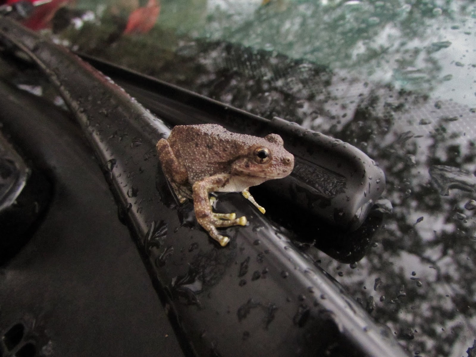
After getting back to camp we enjoyed a great dinner before a quick sunset hike and a trip into Springdale for some ice cream. After a long day of hiking we were in bed pretty early but didn't get much sleep due to a passing storm which left us with some pretty wet camping gear. We were really grateful that the weather as so good to us all weekend and only waited until our last few hours in the park to give us some rain. We woke up at dawn to pack away our gear and say our goodbyes while we thought about where our next trip would be. As we loaded our gear into the car and attempted to drive away I realized that I had left my phone charging too long on my car battery and as a result would not be able to start my car. Luckily a park ranger came to our rescue and with a quick jump we were on our way back to Phoenix, but not before spotting something I had hoped to see all weekend hanging out right on my windshield wiper.

Canyon Treefrog
The Hikes:

- Emerald Pools: 3 miles round trip, 350 ft. elevation gain 
- Observation Point: 8 miles round trip, 2100 ft. elevation gain
- The Narrows to Orderville Canyon: 6 miles round trip, not much elevation gain

Enjoy the outdoors and Leave No Trace!