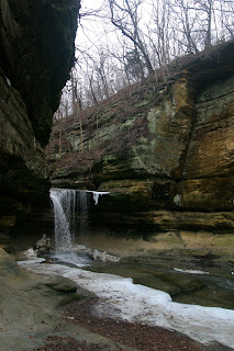
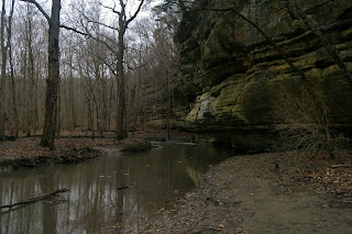
On Tuesday the groundhog (both Woodstock Willy and Punxsutawney Phil) predicted the onset of an early spring. While this means better weather for most things outdoors, it also means I needed to make it a priority to get down to Starved Rock State Park to see the last bit of ice on the waterfalls. My sister had the day off so we headed south for a day hike through some of the state's most beautiful bluffs and canyons.
Located approximately 90 miles southwest of Chicago in Utica, Illinois, Starved Rock State Park gets its name from Starved Rock, a bluff along the south side of the Illinois River. According to legend, in the 18th century a group of Illinois Indians starved to death on the bluff after being besieged by Potawatomi and Fox warriors.The state park, which was founded in 1911, is one of the most beautiful places in Illinois and features beautiful geology, excellent hiking, and scenic views of the Illinois River. Starved Rock is most famous for its sandstone canyons and waterfalls, which were formed over the course of thousands of years of erosion of St. Peter Sandstone during an event called the Kankakee Torrent (17,000-14,000 years ago).
We arrived at Starved Rock in the late morning and parked at the visitors center on the very western edge of the park, where we began our hike. We started on the bluff trail and headed into French Canyon (paying homage to Louis Joliet, Fr. Jacques Marquette, and other French explorers who first came to the area over 300 years ago), which contained a beautiful frozen waterfall. Much of the trail involved hiking on top of a boardwalk, which was installed to protect the highly susceptible soil and rock from erosion. We continued to Wildcat Canyon, which had a much larger frozen waterfall.
 |
| French Canyon |
 |
| Wildcat Canyon |
After passing Sandstone Point Overlook we descended a big set of
stairs and arrived at the river trail. We continued east through
Lonetree Canyon along the trail as it followed the shoreline of the
Illinois River. Hiking along the river allowed us to see another feature
that makes Starved Rock such a cool place: its population of Bald
Eagles. Bald Eagles spend the winter along the Illinois River, peaking
in number in January/February before migrating back north to breed in
the summer. Although I wasn't able to get any good pictures of them, we
saw 8 Bald Eagles over the course of our hike.
 |
| Descending the stairs to the River Trail |
 |
| Two Bald Eagles perched on the Illinois River |
After reaching the river trail the boardwalks ended and the trail turned to dirt, which got a little muddy (good hiking shoes are recommended). The
trail turned away from the shore of the river and we hiked into La Salle
Canyon (Tonty Canyon was closed due to a defunct bridge). The 1/3 mile
side hike into La Salle Canyon terminated at a beautiful waterfall,
which was in full flow due to recent rain. After spending some time
playing with some long exposure photography at the waterfall (I wish I'd
brought a tripod) we made our way back to the river trail.
 |
| La Salle Canyon Falls |
After another short time alongside the river we climbed another set of stairs and found ourselves back atop the bluffs, which provided great views of the river below. We continued on the ridge winding inland around Hennepin Canyon and back out onto the bluffs along the river. We crossed Route 71 just before the turnout for Ottawa Canyon and Kaskaskia Canyon.
 |
| Looking down into Hennepin Canyon from the Bridge |
We decided not to hike into Ottawa or Kaskaskia Canyon in the interest of time (we had been hiking for 3 and a half hours and only had 2 hours of daylight) so we continued on into Illinois Canyon and got halfway through the canyon before reaching a small creek. We opted not to cross so that we didn't have to hike all the way back to the car in cold wet boots but Illinois Canyon was very scenic and probably the widest and largest canyon of any that we had been in.
 |
| Illinois Canyon |
We made our way back to the car following the way we came until we got back past La Salle Canyon. From this point we changed it up a bit and took the river trail the entire way back instead of the bluff trail we had come out on. Along the way we spotted dozens of Downy Woodpeckers and other birds. From the river trail we got a great view of Eagle Cliff Overlook.
 |
| Downy Woodpecker |
 |
| Eagle Cliff Overlook |
We followed the trail to the top of Eagle Cliff Overlook (more stairs, yay!), which provided us with a beautiful view of the Illinois River, the Starved Rock Lock and Dam (which signs pointed out allowed more than 45 million tons of goods to pass through each year) and Starved Rock. We got back to the car just before sunset, 6 hours, 11 miles, and hundreds of stairs later.
 |
| The view from Eagle Cliff Overlook |
 |
| Starved Rock Lock and Dam |
 |
| Starved Rock |
The Hike: Starved Rock State Park from Visitor's Center to Illinois Canyon via Bluff Trail and River Trail, 11 miles, 200 ft. elevation gain (done multiple times!)
Enjoy Starved Rock and Leave No Trace! Seriously though there was alot of garbage along the trail and it was kind of disappointing to see so many people being such pigs.


No comments:
Post a Comment